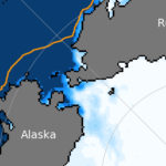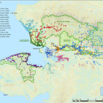

New nautical maps identify Nunavut wildlife hazards for ships
As the Arctic’s sea ice continues to hit historic lows and more vessels clog Northern shipping lanes, the World Wildlife Fund-Canada is reminding pilots to mind their neighbors on the high seas, in the first of a series of maps from the organization identifying ecological habitats.
Access to content from the Arctic Knowledge Archives is available to Passport holders only.
Arctic Today is a non-profit organization, supported by donations from readers like you. While we strongly believe in giving free access to current news for all readers, we reserve content older than one year for our supporters. All individual contributions of at least $20/month or $150/year will receive a Passport to the Arctic Knowledge Archives. Help us drive the leading non-profit editorial team dedicated to delivering context, information and analysis about events in the Arctic.
Already have a Passport? Sign in
choose your level of support and unlock your Arctic Passport.
- Monthly
- Annually
- Groups & Institutions
Individual Annual
$150.00
Year
Individual Monthly
$20.00
Month
Individual Monthly
$20.00
Month
Individual Yearly
$150.00
0