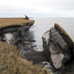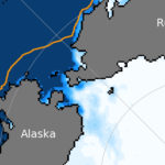

China plans to launch a satellite to monitor Arctic shipping routes
The new imaging capabilities could improve safety of navigation in the icy waters along Russia’s Northern Sea Route.
December 11, 2020
China announced plans to launch a new imaging satellite to monitor Arctic shipping routes. The satellite will employ Synthetic Aperture Radar technology able to observe the Earth’s surface even during night time and through cloud layers or smoke.
Access to content from the Arctic Knowledge Archives is available to Passport holders only.
Arctic Today is a non-profit organization, supported by donations from readers like you. While we strongly believe in giving free access to current news for all readers, we reserve content older than one year for our supporters. All individual contributions of at least $20/month or $150/year will receive a Passport to the Arctic Knowledge Archives. Help us drive the leading non-profit editorial team dedicated to delivering context, information and analysis about events in the Arctic.
Already have a Passport? Sign in
choose your level of support and unlock your Arctic Passport.
- Monthly
- Annually
- Groups & Institutions
Individual Annual
$150.00
Year
Individual Monthly
$20.00
Month
Individual Monthly
$20.00
Month
Individual Yearly
$150.00
0